 |
The Ridgeway |
 |
|
Description |  Step back in time on this wonderful 85 mile route which follows an ancient chalk ridge route used by prehistoric man
The trail starts at Overton Hill in Wiltshire on the edge of the Marlborough Downs and heads east through the Chiltern Hills to Ivinghoe Beacon in Buckinghamshire. Step back in time on this wonderful 85 mile route which follows an ancient chalk ridge route used by prehistoric man
The trail starts at Overton Hill in Wiltshire on the edge of the Marlborough Downs and heads east through the Chiltern Hills to Ivinghoe Beacon in Buckinghamshire.
Highlights on this fascinating route include a series of iron age forts, the beautiful Chiltern Hills and a lovely stretch along the River Thames at Goring-on-Thames.
Please see the map below for a basic overview of this route or |
|
Distance | 86 miles (139 km) |
|
|
Memory Map Route | The Ridgeway.mmo |
|
|
GPX File | The Ridgeway.gpx |
|
|
Elevation | 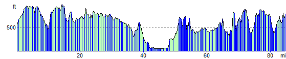 |
|
|
Route Photos |
Photos provided by Panoramio. Photos are under the copyright of their owners.
|
|
|
Map (Route in Red) |
|
|